NIWA's Hotspot Watch for 2 March 2017
A weekly update describing soil moisture across the country to help assess whether severely to extremely dry conditions are occurring or imminent. Regions experiencing these soil moisture deficits are deemed “hotspots”. Persistent hotspot regions have the potential to develop into drought.

Facts: soil moisture
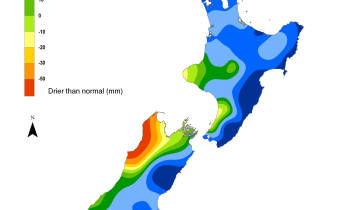
Across the North Island, soil moisture levels have increased due to frequent showers and thunderstorms across the Central Plateau, the Bay of Plenty, Hawke’s Bay, Wairarapa but have decreased elsewhere. The most substantial increases were observed from Tauranga to near Napier and south through the coastal Wairarapa. Meanwhile, the most substantial decreases occurred in western Taranaki and East Cape. Notable decreases also occurred across Auckland and southern Northland. The driest soils across the North Island compared to normal for this time of the year are found in East Cape and Opotiki District, while the wettest soils for this time of the year are found in the Far North and across the Central Plateau.
Hotspots remain in place in East Cape, the Opotiki District, as well as on the Mahia Peninsula. In these areas soils continue to be severely to extremely drier than normal for this time of year. A hotspot has now developed along parts of coastal Taranaki and redeveloped in northern Auckland and southern Northland.
Across the South Island, soil moisture levels have decreased during the past week. The most significant decreases were observed across interior Canterbury, along the West Coast, and in the Tasman District to Nelson. The driest soils across the South Island compared to normal for this time of the year are found in southwestern Southland.
A preexisting hotspot located in the Selwyn and Ashburton Districts has expanded westward into Westland over the last week. A small hotspot is still in place in coastal Hurunui, with new development in Nelson and northwest of Invercargill over the past week.
Outlook and soil moisture
Across the North Island, high pressure will generally cause dry weather through Monday. There will be a few exceptions, however, with isolated showers possible across East Cape and Opotiki (where the driest soils are with respect to normal) totalling less than 5 mm. A weak front will cause a few showers across Taranaki, Manawatu-Whanganui, and western Waikato on Saturday morning with totals generally 5 mm or less. Mostly dry weather is expected across the island on Sunday and Monday. From Tuesday, particularly later in the day, a subtropical area of low pressure may send downpours toward the North Island. A fairly uniform 10 to 25 mm of rain is possible, with localised totals in excess of 50 mm possible across the Central Plateau and from Northland through to East Cape by the end of the day Wednesday. Low pressure is forecast to retreat to the north later in the week, allowing for some drying in the middle and lower North Island but with shower chances continuing across the upper portion of the island. Additional rain amounts may range from 10 to 25 mm by the end of Friday.
For the South Island, rain will move across the far south and along the West Coast on Friday, with totals of 5 to 10 mm in the south but up to 25 mm along the West Coast. Generally dry Saturday and Sunday except for a few showers along the West Coast and far south coast, totalling up to a few mm each day. Showers continuing on Monday in the west and across Southland and Otago with less than 5 mm expected. From Monday night, some heavier falls may move onto the upper South Island, possibly giving appreciable rain to some of the island’s driest regions. Through Tuesday night, a general 10 to 25 mm is possible across the upper West Coast, Tasman, Nelson, Marlborough, and northern Canterbury, with the greatest amounts likely from the Tasman to the West Coast regions where falls may near or exceed 25 mm. At this time, the rainfall forecast for middle and lower Canterbury is less certain. On Wednesday, southeast winds may cause a few showers across Canterbury, generally totalling less than 3 mm. Dry conditions with high pressure are expected to end the week.
Plentiful rainfall across the North Island will likely cause soil moisture levels to increase just about everywhere over the next week. The driest soils (with respect to normal) across East Cape are likely to see significant benefits from the upcoming rain. No new hotspots are expected to develop and pre-existing hotspots may shrink or be alleviated.
Across the South Island, rainfall will benefit dry areas across the west, north, and upper east coast over the next week. Interior Otago and southern Canterbury are expected to have the least amount of rain in the South Island over the next 7 days, so some growing dryness is possible. Overall, hotspot areas are expected to shrink or be alleviated in the north, but areas in the south may remain the same or worsen.

Soil moisture anomaly map for 23 February 2017 as at 9am. [Image: NIWA]

Soil moisture anomaly map for 2 March 2017 as at 9am. [Image: NIWA]
Background
Hotspot Watch a weekly advisory service for New Zealand media. It provides soil moisture and precipitation measurements around the country to help assess whether extremely dry conditions are imminent.
Soil moisture deficit: the amount of water needed to bring the soil moisture content back to field capacity, which is the maximum amount of water the soil can hold.
Soil moisture anomaly: the difference between the historical normal soil moisture deficit (or surplus) for a given time of year and actual soil moisture deficits.
Definitions: “Extremely” and “severely” dry soils are based on a combination of the current soil moisture status and the difference from normal soil moisture (see soil moisture maps at https://www.niwa.co.nz/climate/nz-drought-monitor/droughtindicatormaps)