NIWA weather modelling research aims to improve the accuracy of New Zealand forecasts
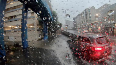
NIWA’s weather prediction model simulated the intense rainfall which fell just north of the capital, and flooded parts of Porirua, on Sunday 27 March. Thirty nine millimetres of rain fell in less than an hour, around 1.00pm.
“The computer model, the New Zealand Limited Area Model (NZLAM), forecast the intensity of this event 18 hours before it occurred,” says NIWA Principal Scientist Dr Michael Uddstrom.
“Although the timing and intensity of rainfall forecast by the 12kilometre resolution model were accurate, it placed the intense rain band slightly to the north of the actual falls. To improve the accuracy of the forecast location, NIWA scientists are developing an even more sophisticated numerical weather prediction model: the New Zealand Convective scale model (NZCONV) – which will provide ultra-high-resolution forecasts to 24 hours ahead.
“If we want to forecast intense weather events, then we need high-resolution models,” says Dr Uddstrom.
NIWA scientists are developing this higher resolution weather prediction model using sophisticated computer modelling. By solving the equations that govern the motion of the atmosphere on a 1.5-kilometre resolution grid across New Zealand, NZCONV will be able to simulate landscape-controlled weather processes over the entire country. The individual areas (cells) covered within the model will be 64 times smaller than those in the current model.
To solve this vast numerical problem, the NZCONV model will use 50% of the capacity of the NIWA supercomputer for one hour, four times daily, while generating each 24-hour forecast.
"Once models like NZCONV are proven, we expect even greater improvement in the forecast accuracy of events like that which occurred on Sunday afternoon,” says Dr Uddstrom.
“We anticipate that we will have some understanding of how well NZCONV performs within three months,” says Dr Uddstrom.
This research, carried out under the weather-related hazards theme of the Ministry of Science and Innovation’s funded Natural Hazards Research Platform is leading to new capabilities for predicting extreme weather events and their consequences – including flooding and inundation.
Preparedness for extreme weather events is critical for saving lives, reducing property damage, and planning business operations.