
December's climate
New Zealand climate in December

Rainfall (click to enlarge).

Temperature (click to enlarge).
December was unusually cool for the first month of summer, due to more frequent than normal southerly winds. Air temperatures were 2 to 3 °C below normal in many places for much of the month. The national average temperature of 13.7 °C was 1.9 °C below normal. The same temperature was recorded in 1946, but since then only December 2004 has been colder, at 13.4 °C.
Rainfall was less than 50% of normal in the north of both the North and South Islands, but twice normal in some eastern areas.
For more information on the climate in December 2006, visit the climate summaries page at www.niwascience.co.nz/ncc/cs/mclimsum_06_12
Dry in Northland and Nelson-Marlborough Soil moisture (click to enlarge). At the end of December soils were drier than normal in much of Northland, and also in parts of Nelson and Marlborough. Soil moisture levels were low also in parts of Gisborne, Hawke’s Bay, and Wairarapa, but soils in many Canterbury and Otago districts were wetter than normal. |
High flows in south and east River flows (click to enlarge). Southerly weather conditions generated high river flows in many catchments in southern and eastern parts of the country, and in some areas of Manawatu and Taranaki. Flows were normal in central and western districts and low in Northland. |
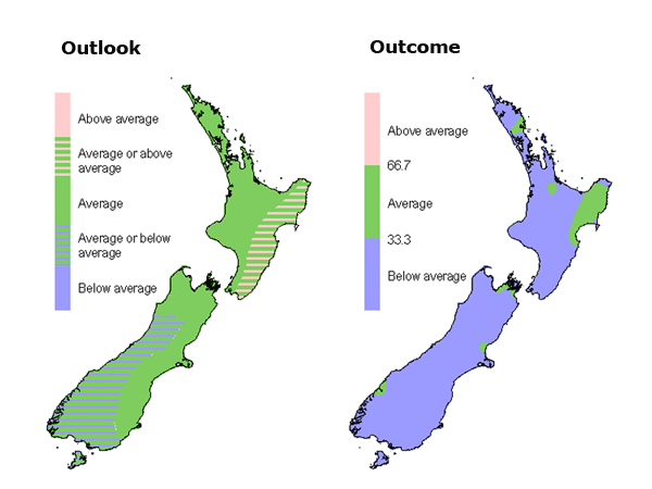
October to December: the climate we predicted and what happened

(click to enlarge).
Rainfall
Rainfall was as forecast in the north of both main islands, but higher than expected in the south of the North Island and east of the South Island. Westland was drier than predicted.
(click to enlarge).
Air temperature
Air temperatures were as forecast for the south and west of the South Island, but lower than expected in other regions.

(click to enlarge).
River flows
Streamflows were below normal as predicted in the north of the North Island, but mostly higher than predicted elsewhere. In many parts of the north and east of the South Island, streamflows were higher than predicted.
The three outcome maps give the tercile rankings of the rainfall totals, mean air temperatures, and mean river flows that eventuated from October to December, in comparison with the forecast conditions.
As an approximate guide, middle tercile rainfalls typically range from 80 to 115% of the historical normal, and middle tercile temperatures range about the average by plus or minus 0.5 °C.