
Three-month outlook
The outlook for November 2004 to January 2004
Atmospheric pressure at mean sea level is expected to be lower than normal to the south and east of New Zealand, with stronger than normal west to southwest wind flows over the country. Sea surface temperatures around New Zealand are expected to be slightly below average (by as much as 0.5 °C) over the next three months.
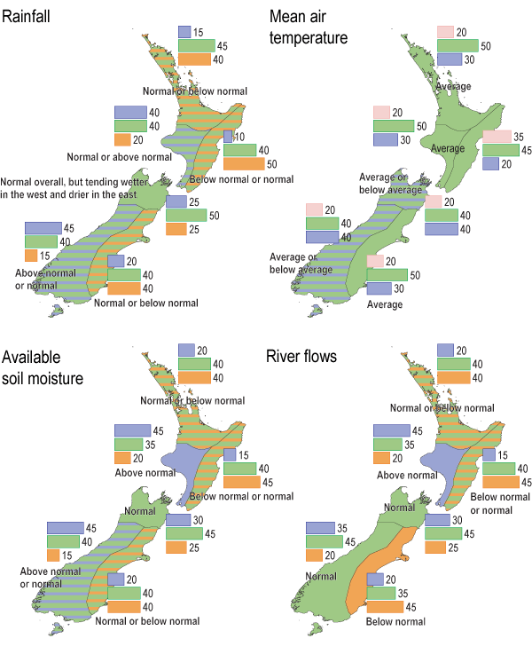
Air temperatures are expected to be near average in the North Island and eastern South Island, and average or below average elsewhere.
Rainfall is expected to be normal or below normal in the north and east of the North Island and the eastern South Island, and normal or above normal in western regions of both islands.
Soil moisture levels and river flows are expected to be normal or above normal in the west of both islands and the south of the South Island, with normal or below normal soil moisture and streamflows in the north and east of the North Island and east of the South Island. Normal soil moisture and river flows are expected elsewhere.
The tropical Pacific is currently in a weak El Niño state, which is likely to continue into early 2005.

A. Climate models give no strong signals about how the climate will evolve, so we assume that there is an equal chance (33%) of the climate occurring in the range of the upper, middle or lower third (tercile) of all previously observed conditions.
B. There is a relatively strong indication by the models (60% chance of occurrence) that conditions will be below average, but, given the variable nature of climate, the chance of average or above-average conditions is also shown (30% and 10% respectively).