A dry start to winter for much of the South Island.
Overview
Mean sea level pressures were higher than normal over the southern South Island and to the south, east and west of the South Island in June 2018. In contrast, near normal mean sea level pressure was observed over and to the north of the North Island. This pressure setup resulted in anomalous easterly and south-easterly winds over New Zealand during June, a pattern that was generally reflected in the rainfall anomalies: dry in the west and wet in the east.
There was a striking difference between western and eastern areas in terms of rainfall for June. The northern and eastern North Island and northeastern South Island bore the brunt of numerous heavy rainfall events from the east. Much of this area received over one-and-a-half times their usual June rainfall, with over 200% of normal June rainfall recorded in some locations. In stark contrast, most of the remainder of the South Island, as well as Taranaki, experienced well below normal rainfall, with less than half of the usual June rainfall falling for much of the South Island.
Temperatures varied during June across the country. It was a warmer than usual June for the north and east of the North Island, but much of the South Island and the southern North Island recorded below normal temperatures for the month. Mean temperatures for the eastern South Island were warmer than usual, a consequence of persistent cloud and resulting in well above average nocturnal (minimum) temperatures. However, the stubborn cloud also resulted in below average daytime (maximum) temperatures. Overall, minimum temperatures were most unusual, resulting in above average mean temperatures. Towards the end of June, several snowfall events and southerly airflows sent temperatures tumbling downwards for much of the country.
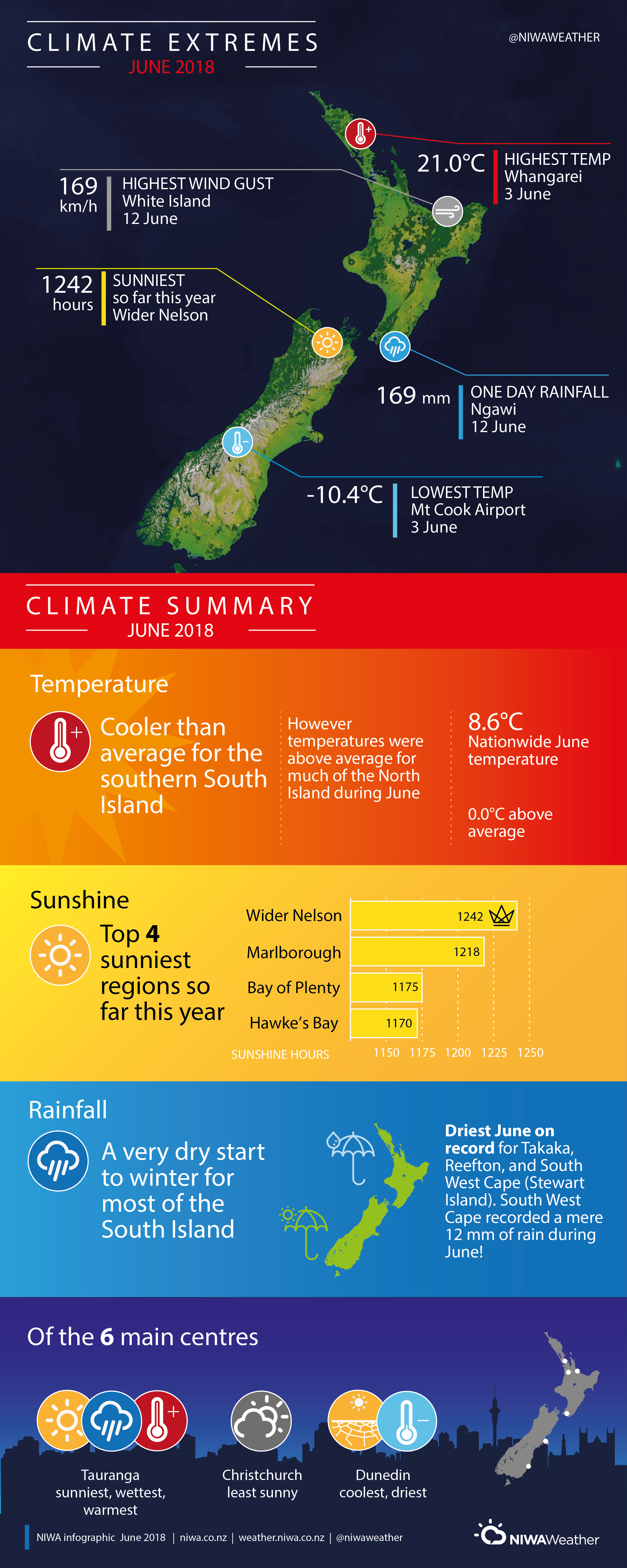
The nationwide average temperature in June 2018 was 8.6°C (the same as the 1981-2010 June average from NIWA’s seven station temperature series which begins in 1909). Based on the seven station series, the first half of 2018 was the fifth-warmest start to any calendar year on record. 2018 sits behind 1998, 1937, 1999 and 2016.
Further Highlights:
- The highest temperature was 21.0°C, observed at Whangarei on 3 June.
- The lowest temperature was -10.4°C, observed at Mt Cook Airport on 3 June.
- The highest 1-day rainfall was 169.2 mm, recorded at Ngawi on 12 June.
- The highest wind gust was 169 km/h, observed at White Island on 12 June.
- Of the six main centres in June 2018, Tauranga was the warmest and sunniest, but also the wettest, Dunedin was the coolest and driest, and Christchurch was the least sunny.
- Of the available, regularly reporting sunshine observation sites, the sunniest four regions in 2018 so far (1 January – 30 June) were Wider Nelson (1242 hours), Marlborough (1218 hours), Bay of Plenty (1175 hours) and Hawke’s Bay (1170 hours).
Contact:
Petra Pearce, Climate Scientist. Tel. 09 375 2052
Download:
- June 2018 Climate Summary information [PDF 500 KB]
- June 2018 Climate Statistics [PDF 63KB]