Climate developments in February 2008

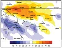
The South Pacific Convergence Zone (SPCZ) extended from northeastern Australia, over Vanuatu and New Caledonia, eastward of Tonga and northeast of New Zealand, with an overall displaced position much further south and west than normal for February. A large region of very suppressed convection persisted along the Equator extending from Western to Eastern Kiribati and the Tuamotu Islands, affecting the regions both north and south of the Equator, including the Northern Cook Islands, Tuvalu, and the Marquesas.
Rainfall was well above average in parts of Northern Australia, and also in parts of New Caledonia, northern New Zealand, Norfolk Island, and Tonga as a result of asouthwest-displaced SPCZ. A new monthly rainfall total was recorded at Lupepau’u, Tonga (383.4mm). New Caledonia also reported a global station average rainfall of 169 % from normal, with a record monthly rainfall at Canala of 945 mm (347 % of normal) and a daily maximum of 279.6 mm on the 27th at that site.
In contrast February rainfall was near or below normal over much of Kiribati, French Polynesia, and parts of the Cook Islands, the Austral Islands and the Marquesas. Rainfall has been below average for each of the past 9 months in Kiribati, and above average during the past 5 months in Nadi, Fiji. Samoa also had multiple stations that recorded below normal rainfall for the month.
February mean air temperatures above average in New Zealand, and were 0.5 ºC or more above normal in New Caledonia, Samoa, and Tonga.
Tropical Southwest Pacific mean sea-level pressures were below average in the north Tasman Sea and to the west of New Caledonia. This pressure pattern produced more north easterlies with abundant rain into northern New Zealand, and heavy rainfall in New Caledonia and parts of northeastern Australia.
| Country | Location | Rainfall (mm) | % of average | Comments |
|---|---|---|---|---|
| Tonga | Lupepau’u | 383.4 | 176 | Record high |
| Kiribatii | Kanton Island | 0.3 | Extremely low | |
| Australia | Willis Island | 533.8 | 270 | Very High |
| New Caledonia | Canala | 945 | 347 | Record high |
| New Caledonia | Poindimie | 729.8 | 206 | Very high |
Soil moisture in February 2008

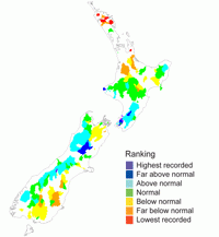
Estimates of soil moisture shown in the map (right) are based on monthly rainfall for one station in each country. Currently there are not many sites in the water balance model. It is planned to include more stations in the future.
The information displayed is based on a simple water balance technique to determine soil moisture levels. Addition of moisture to available water already in the soil comes from rainfall, and losses via evapotranspiration. Monthly rainfall and evapotranspiration are used to determine the soil moisture level and its changes.
Please note that these soil moisture calculations are made at the end of the month. For practical purposes, generalisations were made about the available water capacity of the soils at each site.
Soils continued to be moist (at field capacity) for the time of year at Nadi (Fiji), Hanan Airport (Niue), Apia (Samoa), and in Tonga.
El Niño/Southern Oscillation (ENSO)


During February, the La Niña event that persisted from previous months has reached maturity and conditions continued to spread into the western tropical Pacific. The Southern Oscillation Index (SOI) continued its strong movement upwards, indicating a further strengthening of the ocean-atmosphere coupling.
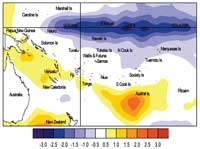
Below normal sea surface temperatures (SSTs) extend across most of the equatorial Pacific, with anomalies of –2.0 °C or lower over the central equatorial region (Date Line to 120 °W, approximately). The warm “horseshoe” is in evidence in the extra-tropics of both hemispheres but remains patchy in the Southern Hemisphere. The NINO3 anomaly was around –1.5 °C in February (December-February average of 1.3 °C) and NINO4 was around –1.6°C (December - February average –1.0°C). In the equatorial subsurface Pacific ocean, a strong eastwest dipole is evident in the temperature anomalies, with the thermocline near the surface everywhere east of 120 °W while the 0–300m heat content increases west of the Date Line.
The easterly trade winds have remained enhanced in February across much of the tropical Pacific, though they have weakened recently near the South American coast. The SOI continues to rise and was near +2.1 in February (DJF average +1.7). This is the highest February SOI value on record for the data set which starts in 1871.
OLR anomalies show an east-west dipole with enhanced convection over Indonesia and suppressed convection from the Solomon Islands to east of the Date Line. The region of enhanced convection that was in the western Pacific has continued to shift westward during the past month. The SPCZ is still prominent but is shifted well to the southwest of its normal position.
The TRMM ENSO precipitation index was –1.3 in February, strengthening from a value of –0.4 in January. The Madden-Julian Oscillation is very weak at present.
All models now indicate La Niña conditions, though some weaken to nearer a neutral state during autumn. Most models indicate La Niña conditions easing to neutral by the end of austral winter. The NCEP forecast indicates La Niña is likely to continue through April–June(though weaker). The IRI synthesis (20 February) suggests strongbut weakening La Niña conditions through April (95% chance) withthe probability of neutral conditions rising to 50% after June 2008.
Forecast validation: December 2007 to February 2008
A La Niña like pattern was expected, with a large region of suppressed convection along the equator from Kiribati, including Tuvalu, Tokelau, and Northern Cook Islands, and the Marquesas, Tuamotu, and Society Islands. Near average or below average rainfall was expected for Pitcairn Island.Enhanced convection was anticipated along a southwest displaced SPCZ extending from Papua New Guinea through the Solomon Islands, Vanuatu, and New Caledonia eastward across Fiji, Wallis & Futuna, Niue, the Southern Cook and Austral Islands, with average or above average rainfall expected in this region.
The rainfall outlook for the December 2007– February 2008 period was very similar to what was forecast, the ‘hit’ rate being 73%. Rainfall was lower than expected in Vanuatu and the Solomon Islands.
