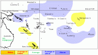
Tropical rainfall outlook: September to November 2006

Most of the seasonal rainfall forecast models are depicting rainfall patterns which are consitent with a weak warm ENSO event for the coming three months.
A large region of enhanced convection is expected to extend from Western Kiribati eastwards to Pitcairn Island including Eastern Kiribati, the Solomon Islands, Samoa, the Southern Cook Islands, Society, and Austral Islands.
Suppressed convection with near or below average rainfall is likely over New Caledonia and the Marquesas Islands.
Near average rainfall is forecast for the rest of the countries in the region.
The forecast model skill is near moderate for most countries.
| Island group | Rainfall outlook | Outlook confidence |
|---|---|---|
| Western Kiribati | 15:40:45 (Near or above average) | Moderate |
| Eastern Kiribati | 20:40:40 (Near or above average) | Moderate |
| Solomon Islands | 15:40:45 (Near or above average) | Moderate |
| Samoa | 20:40:40 (Near or above average) | Moderate |
| Southern Cook Islands | 20:40:40 (Near or above average) | Moderate |
| Society Islands | 20:40:40 (Near or above average) | Moderate |
| Austral Islands | 20:40:40 (Near or above average) | Moderate |
| Pitcairn Island | 20:40:40 (Near or above average) | Moderate |
| Papua New Guinea | 25:40:30 (Near average) | Moderate |
| Vanuatu | 25:45:30 (Near average) | Moderate |
| Tuvalu | 35:40:25 (Near average) | Moderate |
| Wallis & Futuna | 25:45:30 (Near average) | Moderate |
| Tokelau | 30:45:25 (Near average) | Moderate |
| Northern Cook Islands | 20:45:35 (Near average) | Moderate |
| Fiji | 30:40:30 (Near average) | Moderate |
| Tonga | 25:45:30 (Near average) | Moderate |
| Niue | 25:45:30 (Near average) | Moderate |
| Tuamotu Islands | 25:50:25 (Near average) | Low – moderate |
| New Caledonia | 40:40:20 (Near or below average) | Moderate – high |
| Marquesas Islands | 40:40:20 (Near or below average) | Moderate |
NOTE: Rainfall estimates for Pacific Islands for the next three months are given in the table. The tercile probabilities (e.g., 20:30:50) are derived from the interpretation of several global climate models. They correspond to the odds of the observed rainfall being in the lowest (driest) one third of the rainfall distribution, the middle one third, or the highest (wettest) one third of the distribution. On the long-term average, rainfall is equally likely (33% chance) in any tercile.
Forecast validation: June to August 2006
A region of suppressed convection with below average rainfall was expected over Tuvalu, Tokelau, the Northern Cook Islands, and the Marquesas Islands. Near or below average rainfall was forecast for the Tuamotu Islands. A large region of enhanced convection and average or above average rainfall was expected to extend from Papua New Guinea southeast to the Austral Islands, including the Solomon Islands, Vanuatu, Samoa, Tonga, Niue, the Southern Cook Islands, and the Society Islands. Near average rainfall was expected elsewhere in the region.
Areas of enhanced convection or above average rainfall affected the region near Papua New Guinea and the Solomon Islands, as well the region from Niue to the Austral Islands, including the Southern Cook Islands and the Society Islands. Below average rainfall occurred over New Caledonia and the Northern Cook Islands. Rainfall was higher than expected in Tokelau and Northern French Polynesia, and lower than expected in New Caledonia and Vanuatu. Otherwise the overall rainfall anomaly pattern was similar to what was expected. The ‘hit’ rate for the June-August 2006 outlook was about 70%.
