Climate developments in March 2003
Enhanced convection persists, but weaker than in most recent months over Western Kiribati
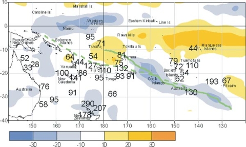
SPCZ further east, from the Cook Islands to the south of Pitcairn
The area of enhanced convection that has predominated over the warmer seas around Western Kiribati since August last year showed signs of weakening in March, with some westward movement to affect Nauru. This is related to the equatorial surface easterlies which strengthened further in March, reaching their highest frequency at Tarawa (92% of observations) since April 2002. The SPCZ continued to be displaced further east than normal, with enhanced convection from the Cook Islands southeast to the region south of Pitcairn Island.
March rainfall was at least 125% of average (and more than 300 mm in places) over parts of Western Kiribati and northern New Zealand, and in a band from the Austral Islands of southern French Polynesia to the region south of Pitcairn Island. Rainfall totals were also 125% or more of average in southern New Caledonia, western and central parts of Fiji (with more than than 400 mm in some areas there), and parts of central and southern Tonga. The above average rainfall in New Caledonia was caused by the passage of tropical cylone ‘Erica’.
A large region of suppressed convection (associated with rainfall totals less than 50% of average) occurred in the southern near equatorial region east of the Tokelau Islands. This region extended well to the east of the Marquesas Islands of northern French Polynesia. Rainfall was also below average over central Tuvalu and Vanuatu.
Air temperatures were 0.5 to 1.0°C above average, consistent with warmer than average sea surface temperatures, in many areas from Western Kiribati southeast to central French Polynesia.
Climate extremes in March 2003
| Country | Location | Rainfall (mm) | % of average | Comments |
|---|---|---|---|---|
| French Polynesia | Gambier | 345 | 193 | Record High |
| New Zealand | Kaitaia | 226 | 290 | Record high |
| Fiji | Savusavu | 104 | 37 | Extremely Low |
| Country | Location | Mean Air Temp (°C) | Departure | Comments |
|---|---|---|---|---|
| French Polynesia | Hiva Hoa, Atuona | 28.1 | +1.0 | Extremely High |
| French Polynesia | Tahiti-Faaa | 28.3 | +1.0 | Well Above Average |
| Country | Location | Max Air Temp (°C) | Date | Comments |
|---|---|---|---|---|
| Fiji | Tokotoko | 34.0 | 15th | Extremely High |
| Fiji | Nausori | 34.6 | 15th | Extremely High |
Tropical cyclone update
There were two tropical cyclones during March, bringing the total to date for the season to eight.
‘Erica’, which occurred from 4–15 March, developed in the Coral Sea and tracked northeast towards, but missing, the Solomon Islands. It then moved southeast to track towards New Caledonia, bringing gales and high rainfall there from 12–14 March (180 mm was measured at Poindimie). Estimated maximum offshore sustained wind speeds reached 260 km/hr (hurricane force), the most powerful this season, with gusts exceeding 200 km/ hr over much of New Caledonia resulting in extensive damage. ‘Erica’ was the worst tropical cyclone to affect New Caledonia in the last 50 years.
‘Eseta’, occurred over 10–14 March, developing west of Fiji. The system moved south at first, and then east-southeast over open seas, with estimated maximum sustained wind speeds of 205 km/hr (hurricane force).
The May issue will provide specific details on impacts of cyclone ‘Erica’.