El Niño/Southern Oscillation (ENSO)
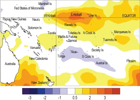
Moderate El Niño conditions exist in the equatorial Pacific. The Southern Oscillation Index (SOI) strengthened considerably in recent weeks, with a February mean of around –2.0 (roughly double the magnitude of the January value). Low-level westerly wind anomalies have been evident in February, especially over the western Pacific. However, Equatorial sea surface temperature anomalies have weakened recently. The NINO3 anomaly fell by about half, to +0.7°C for February, and NINO4 decreased to +1.1°C (from +1.5°C). Upper ocean equatorial heat content anomalies have weakened recently, but a new pulse is evident in the central Pacific, centred near 150m depth. The MJO is weak at present, but is currently configured to reinforce the El Niño pattern, and may have strengthened the atmospheric ENSO signal recently. The MJO is expected to be slow moving but weak over the coming two weeks.
Around half the dynamical models (but no statistical models) NIWA monitor show warm conditions through to the end of May 2010. All models show neutral conditions for winter. The NCEP ENSO discussion of 4 February suggests El Niño conditions weakening to neutral by the end of autumn. The IRI summary of 18 February indicates El Niño conditions continuing with a probability of above 80% through May, then reducing towards climatological probabilities.

Sea surface temperature anomalies (ºC) for February 2010
