Deepsea minerals of the Kermadec Ridge - geophysical prospectivity and environmental impacts
A survey of valuable ore deposits and ecosystems along the volcanic Kermadec Ridge north of New Zealand, designed to inform both potential development and management of seabed resources in the area.
The opportunity
Valuable ores of copper, iron, zinc and gold (seafloor massive sulphides) form from the emissions from hydrothermal vents such as those across the volcanic Kermadec Ridge. These minerals are potentially worth many billions of dollars, but the resource is not yet fully understood. Little is also known about the ecosystems associated with the seamounts on which seafloor massive sulphides are found, which means poorly planned mining could result in major environmental damage.
This research focuses on the Kermadec arc system, and will underpin the discovery and potential exploitation of new seafloor massive sulphide prospects. The research will provide regional and seamount specific biological and physical characterisations. These will inform government agencies responsible for the development as well as environmental management of mining operations, and enable them to develop policies to balance exploitation of a resource with both a high mineral and biodiversity value.
Valuable ores of copper, iron, zinc and gold (seafloor massive sulphides) form from the emissions of hydrothermal vents such as those across the volcanic Kermadec Ridge. Characterising the minerals including understanding their spatial extent is important as potentially they are worth many billions of dollars. Little is also known about the enormously interesting and diverse ecosystems associated with the seamounts on which seafloor massive sulphides are found. Improved knowledge of the areas of mineralisation and biodiversity is critical if we are to ensure sustainable use of these seabed resources.
The solution
The project aims to encourage environmentally sustainable exploration by industry through:
- identifying economically extractable submarine ore bodies around the Kermadec Ridge (each potentially worth NZ$5 billion) and
- assessing the likely seafloor impacts of their exploitation.
The project will do this by mapping the sub-surface structure of known active and fossil submarine hydrothermal / mineralisation systems using multiple geophysical imaging techniques. It will also undertake biodiversity surveys to provide baseline biological datasets that can be used to assess and mitigate the potential environmental impacts of future seafloor mining.
The programme has three key theme areas:
- biological characterisations of the volcanoes of the Kermadec Ridge, to provide baseline datasets from which the potential impacts of seafloor mining in the Kermadec region can be determined
- a comprehensive regional volcano-tectonic analysis to determine the characteristic distribution, scale and pattern of volcanism, including an overview of hydrothermal circulation at a regional scaleand
- characterisation of the sub-surface structure of the submarine arc volcanos using multiple geophysical techniques.
The result
The results for of project will be available in 2013.
The key steps include:
- a voyage in 2010 to Brothers and Rumble II West calderas volcanoes (with University of Auckland and overseas collaborators) to undertake geophysical and biological mapping, and
- interpreting existing regional seafloor mapping data and ROV imagery, including that provided by the project’s industry partner.
- linkages with a voyage in 2011 (in association with GNS and Woods Hole Oceanographic Institution) as part of the Ocean Survey 20/20 programme. This covered several seamounts in the region, including Brothers and Rumble II West to carry out further geological and biological survey work.
More information about Ocean Survey 20/20
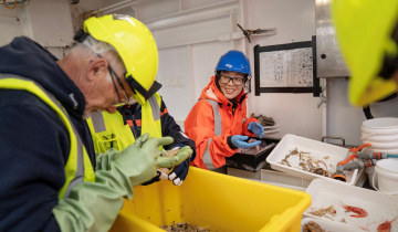
Biological sampling
NIWA’s towed camera system DTIS captured digital video and still images of the seafloor along transects on a number of seamounts. These transects covered a variety of habitats on each seamount, including the summit areas where some hydrothermal venting occurs, inside the old collapsed crater (known as a caldera) and on the flanks of the seamount.
This was complemented by direct sampling with a small epibenthic (near bottom/near seafloor) sledge that collected specimens of the animals seen in the photographs. Initial results show there is considerable variability in benthic communities between seamounts, as well as different parts of the seamount and caldera features.
The sampling revealed a number of species found for the first time in the New Zealand region, and others that are likely to be new species to science.
Contact